Imagine this: After decades of discrimination, hundreds upon thousands of refugees flee to a neighboring country. Decision-makers decide to clear a nearby forest in order to make room for tents from displaced communities. However, the clearing is located in a region that experiences monsoons. The already vulnerable community will be more at risk of flooding and landslides if there are no trees to support the soil.
What went wrong?
Humanitarian relief and disaster response planning often neglect the environment. Without an accurate environmental assessment, disaster response organizations may overlook factors that can increase future risk and loss for vulnerable communities.
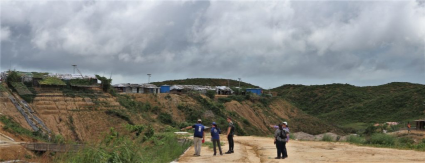
The image above shows the living situation for Rohingya refugees. This is a group of people who fled persecution in Myanmar to seek asylum in Bangladesh. In just three days, 14 inches of rain fell on camps in Bangladesh in July 2019. The torrential rainfall caused 26 landslides that killed one person and left more than 4,500 people without shelter. To address the crisis, the camps now incorporate NASA satellite observations into their decision making to reduce refugee risk from natural hazards. The camp managers now have access maps and a daily-updated web site that provides NASA data about land use, rainfall, elevation. These maps and data combine to give a better understanding of the location and severity of landslide hazards. Although the Rohingya refugee situation is a single example of the effects of environmental neglect in decision making, it is a very real issue for many disaster victims.
Learn more about NASA’s response in the Rohingya refugee crises.
NASA Disasters wants to raise awareness about the importance of the environment in disaster management this Earth Day. The program is supported by organizations such as the United Nations Office for the Coordination of Humanitarian Affairs (UNOCHIM).UN-OCHA), World Wildlife Fund (WWF), U.S. Agency for International Development (USAID), and more to include the environment in the disaster management cycle. These efforts began at the UN Environment / OCHA Joint UnitJEU), which developed the Environment in Humanitarian Action initiative, or EHA Connect. This is the first digital archive of EHA resources and tools to guide environmental considerations in humanitarian action.
Learn more about NASA’s contributions to UN Disaster Risk Reduction Guidelines.
NASA Disasters unique ability to view Earth from space makes it able to incorporate the environment in disaster response. NASA’s Earth-observing satellites allow the program to see how natural hazards, humans, and the environment interact to influence disaster risk. This system view of disasters allows for a more comprehensive approach in disaster response, which leads to lower disaster risk and safer communities around the world.
